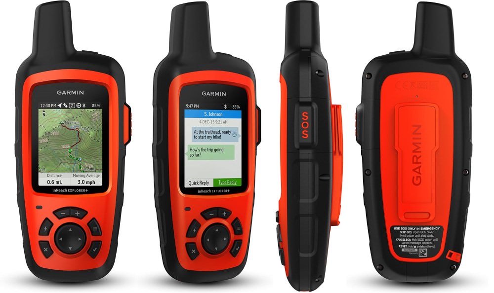
Garmin inReach Explorer+
Pros
- Reliable, global satellite network
- Unlimited Sending of (Customizable) Preset Messages
- GPS Navigation with Maps
- SOS Emergency Function
- Long battery life
Cons
- Expensive satellite subscription plans
- Messages can take a while to send/receive
- Only one color choice
- Text messages may not work reliably

Contents
Peace of Mind
I am an avid hiker, camper, wilderness backpacker, and traveler. Last week, I took my 4.5 year old son on his first-ever backpacking trip, and naturally, his mother was very worried for his safety. We cannot recount the number of times over the past decade where our groups had near-death encounters with rattlesnakes, beginning hikers (or arrogant experienced ones) getting separated, or instances where someone wished they could let a loved one know they were okay. Add children into the mix, and the ability to send re-assuring messages to loved ones becomes ever more so important.
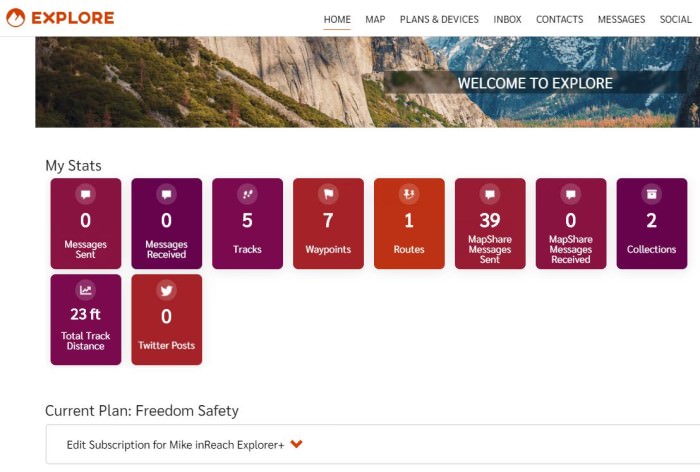
We compromised by purchasing a Garmin inReach Explorer+ with the Safety “Freedom” Plan for the occasional wilderness treks.
In this review, I will describe topics that include:
- Differences between the inReach Explorer+ and inReach Mini
- Garmin inReach vs SPOT satellite coverage
- Satellite communication plan options
- Free custom messages I have pre-programmed
- SOS Function of the inReach
In A Nutshell
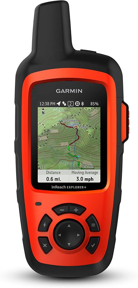
Credit: Garmin
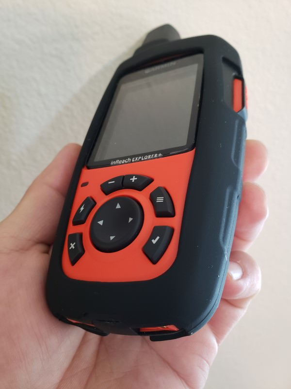
The Garmin inReach Explorer+ has provided my family some peace of mind when going out into an area that has no cell phone signal, such as the wild, California Sierra Wilderness. Once activated, it becomes an almost set-it-and-forget-it affair, and one only would have to remember to send an occasional, free message that the group was okay. Battery life is excellent, and having the ability to check topographic (or other types of) maps aids with navigation where you could literally and truthfully tell someone that the destination is just “5 minutes away”.
To use the emergency and messaging functions, a satellite communication subscription is required, of which there are various options for annual and monthly (30-day) contracts. The Annual plan is more cost effective if you intend to use the service year-round, and the Monthly one is best if you only want to turn on services for 30 days at a time for (generally) less than 7-9 months of the year. No subscription is needed to use the inReach as a standalone GPS navigation device. Because the inReach Explorer+ has a better satellite lock than the smaller inReach Mini, it can more reliably and better communicate with rescuers. This can be the difference between life and death as every second counts! The Mini has no built-in GPS map and relies on a smartphone for mapping, and thus require two devices to stay charged for full functionality.
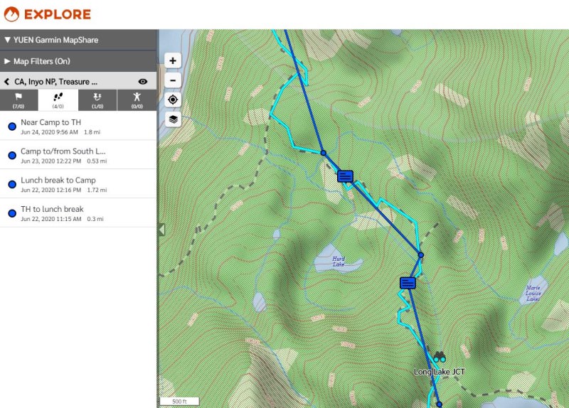
One can send the current location to Garmin’s free MapShare web service where contacts can follow along on your trip, complete with tracking routes, waypoints, messages, and more.
The inReach Explorer is better than the SPOT communication device because it has much better satellite coverage (both in the USA and internationally) and allows for free sending of custom preset messages. The inReach Explorer+ is an excellent device for taking on a trip where the cost of life is worth much more than the subscription. I am very happy to own such a device and can now more confidently travel with my young child without worrying my family too much.
Iridium Satellite Coverage
By far, the Iridium satellite network covers the globe better than competing Globalstar (which the SPOT satellite messenger uses). In fact, SpaceX launched 75 new Iridium satellites into space in 2019 to replace the older, 1997/2002-era ones.
The Satellite service enables two-way texting and multiple subscription plans are available.
inReach Explorer+ vs Mini
I chose the larger Garmin inReach Explorer+ over the inReach Mini because:
- Longer battery life
- Better suited for longer treks lasting more than 1-3 days
- During my June 2020 trip, it still had 60% of battery left after 3 days
- Better satellite lock
- This can mean the difference between life and death! The better the lock, the better and faster you can communicate back and forth with the rescuers
- GPS maps
- Pre-loaded, free maps (including city, topographic, satellite aerial color images, etc)
- Acts as both a Satellite Communication (subscription required) and a standalone GPS Navigation device
- Color screen
- Graphical interface
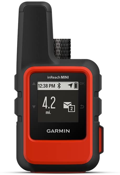
inReach Mini /Garmin
inReach Mini is better than the Plus version because:
- Well-suited for shorter treks lasting 1-3 days
- Lighter in weight
- Slightly cheaper
- Smaller
- Newer technology and can communicate with a supported Garmin watch
Detrimentally, the Mini requires a smartphone for visual GPS maps and thus needs two devices to stay charged for full functionality. Keep in mind that smartphones are not rugged: if its screen breaks, you may find yourself in a difficult situation.
Both Explorer+ and Mini are able to communicate with the Garmin Earthmate app via Bluetooth to exchange information or provide enhanced user interfaces. Both are also waterproof with an IPX7 rating, allowing them to be submersed in 1m/3.2′ of water for up to 30 mins.
From anecdotal stories I had read, the inReach Explorer+’s better satellite lock makes it a better choice over the inReach Mini for more reliably and quickly communicating with rescuers during an emergency situation.
Satellite Communication Plan Options
I only backpack occasionally, but when I do, safety is always at the top of my mind. Yet, I never wanted to purchase a satellite communication device because the service plans were always so expensive. If your life were in danger, however, then no cost can make up for that, especially when your own child is in trouble.
Activating the inReach device did not go smoothly. The first time, it failed to see that I had already purchased a Safety Freedom plan, but after rebooting it and retrying, it worked.
Messages are not sent in real-time. It heavily depends on how good the link between you and the satellite is, and the inReach is set to check for new messages every 10 minutes by default. You can, however, manually check for messages, but keep in mind that this can drain the battery. SOS messages receive priority over the most recent messages.
The plan we chose was the “Safety” monthly, 30-day plan. The way it works is as follows:
For more details on Subscription options, visit Garmin’s inReach or Subscription Plans page.
Annual Plans
- For year-round service at a lower, monthly cost
- For the “Safety” plan, the Annual option is better than Monthly when you use the service for 9+ months of the initial year and 7+ months every year thereafter (saving is from having no annual activation fee)
- Contract length: 1 year
- Cannot be suspended/paused
- Activation fee: $30 each time service is started/restarted
- There is no additional activation fee for as long as you continuously maintain an Annual plan
- Can move up/down between Annual Safety, Recreation, and Expedition plans without a change fee
- Changes go into effect immediately
Monthly “Freedom” Plans
- For occasional service (turn on only for the month you want to use it for)
- Suitable for single adventures
- Contract length: 30 days
- Auto-renews every month
- Can be suspended/paused (or cancelled entirely)
- Activation fee: $35 annually (up from $25 in 2020)
- Charged on anniversary of subscription activation date
- If you SUSPEND your plan, you will still be automatically charged the activation fee on your anniversary date
- You can only avoid the activation fee by CANCELLING. That will also delete all your existing online data/configuration stored by the Garmin service
- Can change to Annual plan without an activation fee
- Charged on anniversary of subscription activation date
- When SUSPENDING (pausing), service will continue through the end of the paid, 30-day period
- If you paid for April 1 – April 30 and you suspend on April 8, service will stop on April 31
- Can move up/down between Monthly Safety, Recreation, and Expedition plans without a change fee, but you have to stick with the chosen one for 30 days
- Changes go into effect immediately
- Tip: Make the change a few days before the end of the current subscription or you will lose whatever was left for that period
- Example: If your plan ended on April 31 and you changed on April 21, the NEW plan would start that day. You will have lost the remaining 10 days you had with the previous subscription
- Changes go into effect immediately
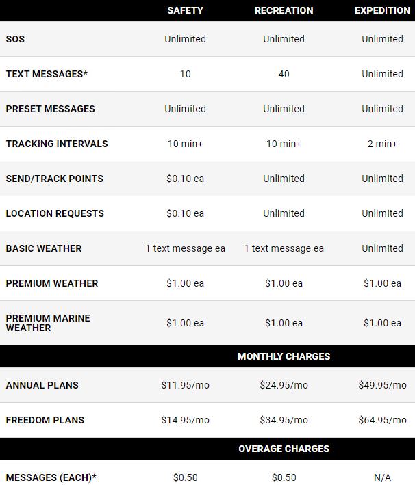
inReach Subscription Plans as of April 2021 /Garmin
The reason we chose the Safety “Freedom” plan is that it is the cheapest ($15/mo) for emergency use. All I wanted was the ability to send free, unlimited “We are OK” messages and remit (paid) custom ones as needed. The Safety monthly plan includes:
- Unlimited sending of free Preset Messages (you are allowed 3 presets). I will share later how I set mine up
- 10 Custom text messages. Each additional ones (both sending and receiving) cost $0.50
- Unused ones do not roll over to the following months
- Tracking Points to let people know where you have been at $0.10 each
- Those who want to know where you currently are can submit a Location Request for $0.10 each
I had no intention to send custom messages or to be in constant, two-way communication with my family. All they needed to know was that we were okay, and if they did not hear from us for four hours, to then send us an emergency message to see how we were doing before they would start to worry.
If you intend to write or receive a lot of custom texts (and/or send enough tracking info) that would total to $20, then you may want to consider purchasing the $35 Recreation “Freedom” plan for the month instead. I did not foresee to spend $20 (difference between Safety and Recreation monthly plans) worth of services, and Safety was perfectly fine for my purposes.
When you are done with your trip, don’t forget to SUSPEND (not “CANCEL”) your Monthly plan! The service will continue through the end of the paid, 30-day period.
A subscription can only be active on ONE Garmin device at a time. To use multiple devices, separate accounts and subscriptions will need to be set up. You can move a subscription between devices.
Pre-Programmed Messages
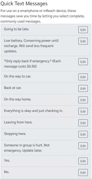
Quick Text Messages
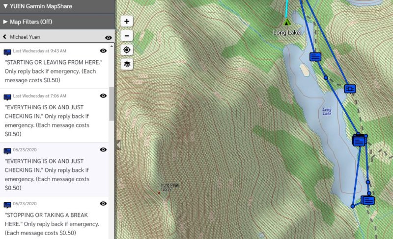
You are given 3 Preset Messages (which includes your current location) that you can send an unlimited amount of at no extra charge (free!) Here is how I set mine up (along with a reminder that a reply would cost 50 cents):
- “EVERYTHING IS OK AND JUST CHECKING IN.” Only reply back if emergency. (Each message $0.50)
- “STARTING OR LEAVING FROM HERE. If sent 2x with no other msg in-between: Leaving this camp/overnight stay.” Only reply back if emergency. (Each message $0.50)
- “STOPPING OR TAKING A BREAK HERE. If sent 2x with no other msg in-between: Staying here overnight.” Only reply back if emergency. (Each message $0.50)
Each of them would be sent to an email distribution list containing members who needed to know where we were PLUS a text message to some VIP people such as my wife. Note that text messages may not reliably work (depending on carrier issues and other factors), and one reason I opted to send to both text and email. You could also send trip data to Garmin’s MapShare web service with an optional password for others to access it.
Garmin MapShare
Garmin offers the free MapShare service, a website that you can share with friends and family to interact with you, such as seeing where you are, what messages were sent, and optionally, to send you messages and/or make location requests. The website would be https://share.garmin.com/your_custom_name, where “your_custom_name” is chosen by the device’s owner. The owner can set from which date people can view trip data from, helping to ensure privacy on past trips made.
Social Networks
You could also share trip data to Twitter and a Facebook Group, although I am not happy with the latter. I would have much preferred to have been able to publish ONLY to my Personal account’s Newsfeed with options to configure who can see the information.
Tracking
There are two options that can be configured:
- Log Interval
- How often the GPS checks for and records your current location. The more often, the more battery is consumed
- Data is stored locally onto the inReach device (there is no fee)
- Only logs your route. Nothing is sent to your Garmin account or MapShare web page until you sync device with a computer via USB cable or through the Earthmate smartphone app
- Allows you to view your exact route once you are home or have Earthmate synced with the GPS
- Default: Every 1 minute
- How often the GPS checks for and records your current location. The more often, the more battery is consumed
- Send Interval
- How often the GPS sends your current location, elevation, speed, and heading to the MapShare page
- Each of these is a “Tracking Point” ($0.10 each on the Safety Freedom plan)
- Unlike “Log Interval” that only saves your location history (for free) onto your inReach device, “Send Interval” actually sends information to your Garmin account for a small fee
- Default: Every 10 minutes
- How often the GPS sends your current location, elevation, speed, and heading to the MapShare page
Garmin inReach/Explore Dashboard
SOS Function
I have not tried the SOS functionality, though I did briefly push it to see what would happen. It sounded a loud alarm, but I stopped it before SOS was activated. When activated, you would be put in touch with the GEOS Response 24/7 global network. If an emergency is confirmed, GEOS will reach out to local emergency responders and later also update your emergency contacts (if set up).
Update: On January 5, 2021, Garmin announced the acquisition of GEOS and its IERCC (International Emergency Response Coordination Center). With that, the cost of the annual activation fee for Monthly subscription plans increased from $25 to $35.
Garmin does not charge for messages and tracking sent between you and GEOS. SOS use is, at the time of this writing, unlimited with the subscription, and tracking automatically gets turned on. Rule of thumb: If you would have called 911 Emergency for an event, SOS could be used for that reason too:
- Example: If you come across a wildfire, you can activate SOS to inform the GEOS Response center
- GEOS will pass the information over to the appropriate authorities
- You will NOT be charged a fee for communicating with GEOS
Any charges between you and other parties that GEOS puts you in touch with (ie. Police, Coast Guard, Search & Rescue, etc.), however, are for the person the SOS was activated for. This means that if you come across an injured person, and that person needs help, you can activate SOS and THAT person (not you) would be financially responsible for the rescue. You would only get charged if the emergency is for yourself or for someone you are financially responsible for.
Garmin stated in a 2021 webinar that if you activated SOS for a third party, that person would be financially responsible, not you, if a rescue is mounted.
SOS can be cancelled when no longer needed. To activate SOS, note that an inReach satellite subscription is required. The SOS button cannot be accidentally triggered: you would have to remove the protective cover and hold the button for a few seconds until the SOS countdown appears. SOS can be turned on even when the device is powered off.
You may want to consider GEOS SOS insurance at $18 a YEAR which covers up to $100,000 in search and rescue expenses ($50,000 per incident). There also is insurance available for medical evacuation to a hospital near your home ($130/year for US & Canada, $175 for International).
Tips
Subscription Activation
If you have activated a subscription plan, leave your Garmin inReach by the window (or outside) to let it sync with the satellites. You will eventually receive a free text message on the device that says: “Welcome to the inReach! Check out all of the great messaging, tracking, and social features. Reply to test. 5 free messages per month.”
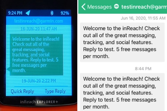
Message after subscription activation. Left: inReach. Right: Garmin Earthmate app
You should then be able to see your “Plan Renewal Date” and “Plan Details” under “Data Use” on the inReach. You may have to tell the device to “Check for Update” on that screen. Finally, you should either send a Test message (up to 5 free/month) or one of your Preset Messages (free and unlimited) to confirm communication is working.
Reminder: When you are done with your trip, don’t forget to SUSPEND (not “CANCEL”) your Monthly plan or it will auto renew! The suspension is not immediate — the subscription remains valid through the end of the paid, 30-day period. Example: If you paid for April 1 – April 30 and you suspend on April 8, service will stop on April 31.
Be aware that when your Monthly plan is SUSPENDED, the annual activation fee will still be charged on the anniversary date. The only way to avoid that is to CANCEL, but that will also delete all your existing online data/configuration stored by the Garmin service.
Before A Trip
I would perform the following tasks before you go out on a trip:
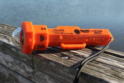
See-Me 2.0 Water-Activated Strobe /ust
- Have all your emergency gear prepared, tested, and ready for packing
- See some Safety Gear recommendations after this section below
- Research your trip location, including terrain, water, and weather conditions, as well as local rules and regulations
- Program your Preset Messages and Custom Text (for quick selection) messages
- Populate your Contact List on the Garmin inReach website and sync to your device via the Earthmate app
- On the inReach website, you can set up Waypoints and Tracks to help with navigation
- This can also help inform your contacts of the route you plan on taking
- Run a free test from the inReach device or website. You are allowed 5 per month
- A test message would have the inReach send a message to the satellite, and the satellite would send a reply back
- Turn off Bluetooth on both the inReach device and your smartphone (where EarthMate is installed) to conserve battery life
- Only turn on for syncing as needed
- Only 1 Earthmate app/Smartphone can be connected to inReach at a time
- I tried to connect two phones to the inReach device and that was not allowed
Before you go on a trip. (1) Send some Preset Message tests (they are unlimited and free) to ensure your Garmin works. (2) Update your Emergency Information, including your trip itinerary and number of people with you, on the Garmin Explore website. (3) Inform your emergency contacts of your trip plans so they have a rough idea of where you will be on each day. (4) Share your Garmin MapShare link with your contacts.
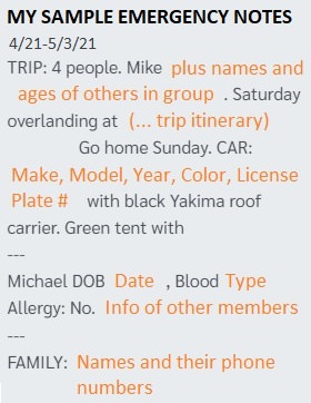
Sample of my Emergency Notes on Garmin Explore
- Fill in your Emergency Information at the Garmin Explore website
- If you trigger an SOS, the GEOS operator will be able to see this information and relay it to the emergency responders to help with rescue. This video by Garmin explains more
- Contacts: Who to contact (name, phone, email)
- Notes (500 characters max)
- Medical information (ie. allergies)
- I would also include a brief description of your trip details
- Trip date and itinerary
- So rescuers won’t receive outdated trip info in case you forgot to update. It could be really bad if you activated SOS and you were actually somewhere else (although the operator should be able to see your current location)
- Number and ages of people with you, identifying things (like jacket colors or car info), etc.
- Trip date and itinerary
- Send some Preset Message tests
- They are unlimited and free. Verify that email, MapShare, and texting to your contacts work
- Text messages may not reliably work (depending on carrier issues and other factors), and one reason I opted to send to both text and email
Usage And Messaging
- Turn on the inReach device at the start of the trip and wait for it to have obtained connectivity with the satellite(s)
- Send a message to your contacts that you have begun and start tracking function as needed
- Have a clear, unobstructed view of the sky
- inReach should have its antenna pointed up towards a clear, unobstructed view of the sky. Ensures the device will have the best signal with the satellite(s) for more efficient/reliable communication and less delays
- Data Sync Priority Levels
- The inReach, according to Garmin, will synchronize data in the following order of priority: SOS > Most recent message > Track points
- You may use the Mail Check feature to initiate sync before the next check internal
The inReach, according to Garmin, will synchronize data in the following order of priority: SOS > Most recent message > Track points
- Tether/Secure the device
- Strap the inReach to your backpack’s shoulder strap at the front so it can easily be reached in an emergency. Be sure the antenna points up towards the sky
- You should have the device protected (especially the screen) with a case or sleeve
- You may put it inside the backpack or pocket, but be sure you can reach it for a SOS
- Do not hang the device around your neck because if you fall, it may drop off or you may get strangled
- Strap the inReach to your backpack’s shoulder strap at the front so it can easily be reached in an emergency. Be sure the antenna points up towards the sky
- Keep your contacts informed
- Notify your contacts via a preset or custom message when you have started your trip, plan on making any changes to the itinerary, and when you have finished
- After completion of the trip, stop tracking and allow any unsent messages and track points to sync before turning off the device. The inReach will inform you if any unsent data has not yet synchronized
- SOS Emergency Use
- Garmin does not charge for messages and tracking sent between you and GEOS when SOS is activated
- Rule of thumb: If you would have called 911 Emergency for an event (such as coming across a wildfire), SOS could be used for that reason too
- GEOS will pass the information over to the appropriate authorities. You will NOT be charged a fee for communicating with GEOS
- SOS can still be turned on even when the device is powered off
- Tracking is automatically turned on during SOS activation
Safety Gear
These are the items I take with me on every trip:
For inReach Explorer+
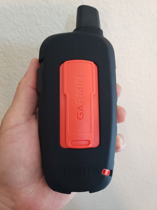
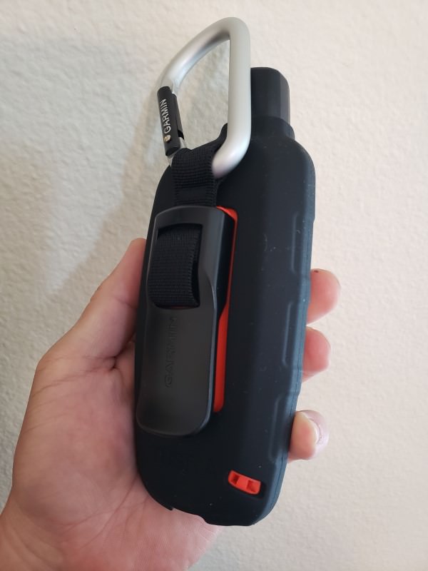
- Tempered glass screen protector (bought one by Tusita)
- Case or sleeve for additional protection (bought a silicone sleeve by Tusita)
General safety gear
- LED beacon strobe light for emergencies, such as the ust See-Me 2.0 Strobe
- Car battery jump starter (favorite: NOCO Genius)
- I had helped a countless number of people (and myself) with cars that could not start in the middle of nowhere and no cell phone reception
- Portable tire inflator
- If your car gets stuck in the sand, you should deflate the tire(s) to help with getting out. You would then need an inflator to bring them back to recommended pressure
Final Thoughts
Overall, I am really happy with the device. The inReach Explorer+ is so fun to have as a microUSB-rechargeable, navigation GPS with free, topographic maps and the ability to send and receive text messages. It has brought a lot of peace of mind to my family whenever I sent FREE, hourly “We are okay. Just checking in” messages, and knowing that if we were in a true emergency, we could activate the SOS button from anywhere in the World.
It is worth mentioning that because the inReach Explorer+ has a better satellite lock than the smaller inReach Mini (and has better satellite coverage than SPOT’s Globalstar network), it can more reliably and better communicate with rescuers. This can be the difference between life and death as every second counts in an emergency situation! Our family also chose the Explorer+ for its built-in, subscription-free GPS mapping functionality. This allows us to have free maps (USA and international) pre-loaded so we can always navigate or explore from the device itself. Speaking of which, you should always have paper maps available in case electronics fail.
Check out: ACR ResQLink – When you only need to call in for rescue (no communication or mapping). No monthly fee, but battery only lasts 5 years and needs to be professionally replaced.
Good read: Takeaways From a Terrible Fall and Lifesaving Rescue
Where To Buy
- Satellite Communicators
- Garmin inReach Explorer+
- Tusita Tempered Glass Screen Protector
- Tusita Sleeve
- Garmin inReach Mini
- SPOT
- Garmin inReach Explorer+
- Satellite Rescue Beacon
- ACR ResQLink – When you only need to call in for rescue (no communication or mapping)
- Emergency Gear
- ust See-Me 2.0 Strobe
- NOCO Genius Car Battery Jump Starter – See our Review